We received this email from a resident who lives very close to Rocketdyne...
Date - November 12, 2018
Subject - Rocketdyne Melt Down
Mr. Rense,
I live about two miles from Rocketdyne and a good friend works for them, and has been on the site numerous times.
He told me that the original reactor meltdown is still going, working its way deeper and deeper into the earth.
There is no end in sight. Thats all that I can say.
Anonymously yours
Jeff,
Consider this a possible follow-up contribution to https://rense.com/ general96/socal-fire-released- readly-radiation-and-toxins. php
You should watch this video immediately:
https://www.nbclosangeles.com/ investigations/Is-Smoke-From- the-Woolsey-Fire-Toxic_Los- Angeles-500338322.html
Basically, KNBC-TV broke ranks with the rest of the L.A. MSM last night (5 PM November 12 newscast) and aired that video report essentially confirming a probable large radiological release at the old Santa Susana meltdown site. The video offers the following:
- helicopter footage of the exact portion of the power lines which appear to have started the fire (00:39 in the video) - helicopter footage of the Santa Susana site on fire Thursday night, confirming what you saw on KTLA and put into your article above (00:47) - documented confirmation from SCE of the exact location of the portion of the power lines which started the fire (00:55 -- "E and Alfa Streets")
- reporter mentions that this location was the site of the nuclear meltdown 60 years ago (01:00)
- he points out that the State of California assured nearby residents there was no risk when the fire began (01:10)
- helicopter footage of the substation at which the power line fault was detected (01:40)
- documents confirming that the substation is located within the immediate vicinity of the meltdown (01:46)
- helicopter footage showing that the burning power lines are mere yards from the substation (01:50)
- reporter says that the fire then spread from there to much of the remainder of the contaminated property, in case things weren't bad enough already (01:55)
- report concludes with Dr. Robert Dodge, Physicians for Social Responsibility, confirming the smoke probably contained toxical chemicals "and radionuclides" (02:04)
When I saw this video on KNBC, I immediately did a little investigating of my own via Google Earth. Alas, what I found will probably send the same chills down your spine as I experienced:
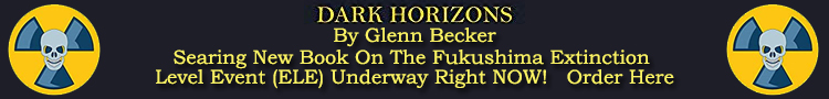
• Look at e-mail attachment #1 ("ss01.jpg"). This is a Google Earth view of the most contaminated portion of the site (known as "Area IV"). I enabled several of the Google Earth Community information anchor points (the blue "i" icons), one of which indicates the exact meltdown location. As you can see from this image, the substation in question, and the meltdown site, (not to mention several other labels indicating things like "crazy amounts of waste and barrels"), are all only 450 yards or less apart from each other;
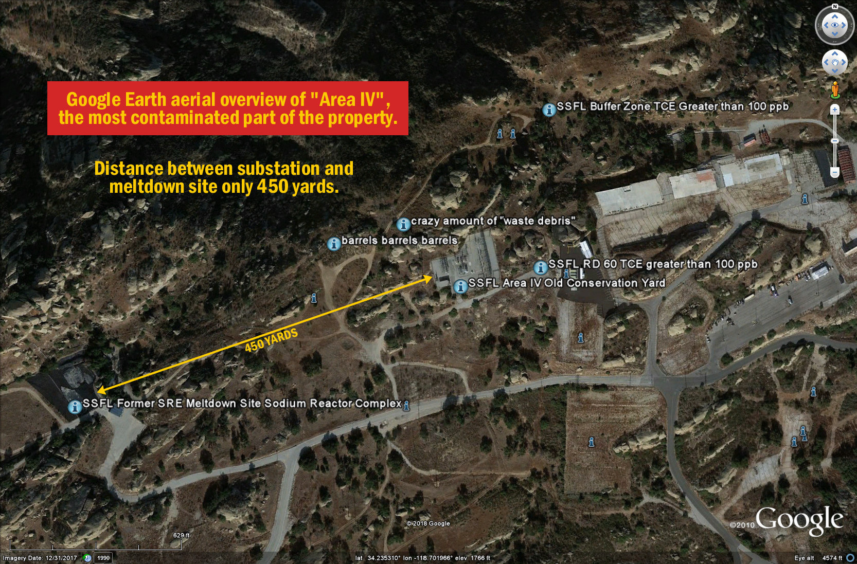
• Next look at e-mail attachment #2 ("ss02.jpg"). This is a comparison between KNBC's helicopter footage of the culprit substation, and a Google Earth zoom-in on the same substation you see in attachment #1, simply to prove that I found the correct substation with Google Earth. As you can see, despite the difference in orientation, this image confirms them to be the same.
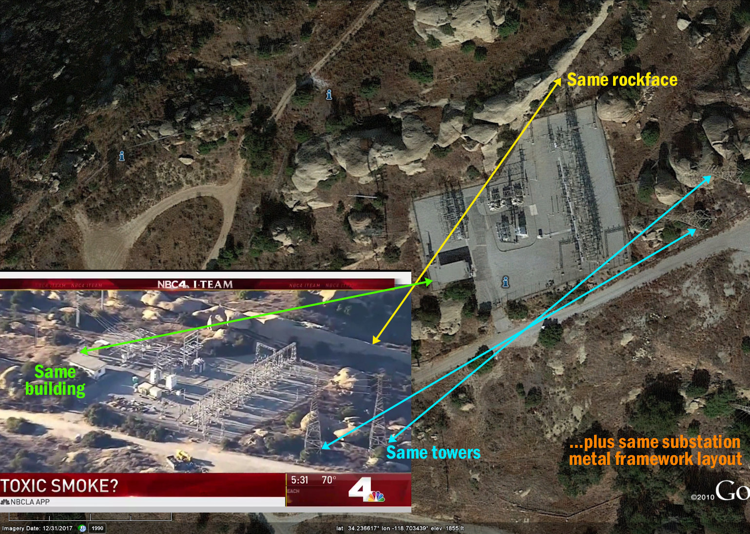
• Finally, look at e-mail attachment #3 ("ss03.jpg"). This is Google Earth with the Roads overlay enabled, so you can see the street names. Inset into this image is a different moment from the KNBC video, wherein both their on-screen graphics (of Southern California Edison's documents), and their reporter's voiceover, are indicating that the fire began in the area of "E Street" and "Alfa Road". Both seem to shy away from indicating just how close the fire's flashpoint was to the meltdown site, suggesting it was "in" or "south of" "Simi Valley". But as you can see, this image basically shows that the ignition point was practically on top of (within 450 yards or less of) the actual super-specific, pin-point ground zero location for that 60 year old meltdown. :-(
Jeff, suffice it to say, I am very worried. It APPEARS that not just "the facility" went up in flames, but that in all likelihood, the actual meltdown site was included in the burn area, if it wasn't the first to burn. If this is true, then in all likelihood, Southern California -- and especially everyone southwest of the meltdown site (i.e. Thousand Oaks, Calabasas, Agoura Hills, Westlake Village, Topanga, Malibu, Bell Canyon, etc.) -- spent at least one day breathing in a massive release of radioactive smoke ... made of particles which have now undoubtedly settled all over the greater socal area, and into the ocean just offshore.
I sincerely hope I am wrong. But at this point, I don't see how I could be.
|