- Errrr...that huge "tail" Alex developed (which
I've never, ever seen before on a hurricane in the decade I've been watching)
is being lopped off and it looks as though Alex is going to spin down around
counterclockwise back into the Gulf and form again into something tropical
over the weekend! See also the Accuweather report immediately below this
radar map.
-
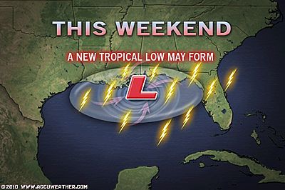
- Watching Central Gulf Coast for Tropical Development
- By Alex Sosnowski, Expert Senior Meteorologist
- Jul 1, 2010; 1:00 PM ET
-
-
- Moisture lingering along the central Gulf of Mexico near
Alex will be watched closely for possible development this weekend, since
atmospheric gears are already in place.
- It is highly unusual during July to get a front buried
as deep into the South as we do this week. Sometimes, when this happens,
a tropical system can form.
-
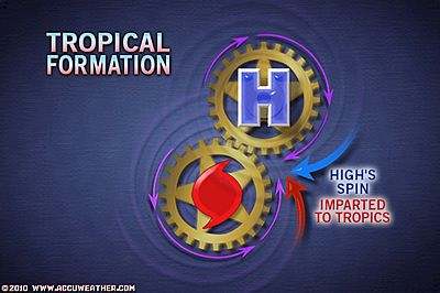
- A massive area of high pressure spinning clockwise to
the north would seem to be a deterrent for that sort of problem. However,
things are not as they appear.
-
-
-
-
- The northeast wind created by the high to the north,
combined with a south to southeast flow over the north-central Gulf of
Mexico, may be enough to get the atmosphere spinning counterclockwise,
the motion needed for tropical cyclone development.
-
-
-
-
- We already have a zone of drenching showers and thunderstorms
in place, delivered in part by Alex's northwest movement from the tropics
last weekend and in part by the upward motion along the old stalled front
nearby.
-
- Look for the zone of unsettled weather with locally drenching
showers and thunderstorms to continue through the weekend from Florida
to coastal Texas this weekend. What is left of weak circulation of Alex
could drift into western Texas or New Mexico, well away from the Gulf
Coast.
-
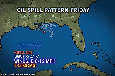
- While the gusty downpours along the Gulf coast will offer
some temporary relief from the heat, they will cause disruptions to
containment and cleanup operations on the beaches and offshore.
-
- While the risk of full tropical development is not extremely
high this close to the coast over the next three to five days, the chance
is far from zero. The area is of concern to Hurricane Expert Joe Bastardi
and many other AccuWeather.com meteorologists.
-
-
-
-
- The lingering thunderstorms from the Florida Panhandle
to coastal Louisiana could slowly brew the next tropical disturbance or
depression of the 2010 Atlantic Hurricane season.
- Any system that forms in this immediate area could lead
to more extensive disruptions for oil spill cleanup and containment
from squalls and building wave action.
- The circulation around any system that forms could drive
oil inland or to more distant locations.
-
- http://www.accuweather.com/blogs/news/story/33445/watching-central-gulf-coast-fo.asp
|