-
- From Denis Robertson vadar@nobbys.net.au
- 6-6-00
-
- Jeff,
-
- I've been following your reports on the "contrails-chemtrails"
saga with great interest and hope that the accompanying photos may be
a useful addition to somebody's files, because thís sequence shows
a clear development from the initial thin contrails to the thick and unnatural
cloud-cover.
-
- These photos were taken last Sunday (4th June) in country
New South Wales (Australia) over the quiet upper Hunter Valley ,100 km
inland from the eastern coastal city of Newcastle, between about 9.30
and 11.30 in the morning. These are by no means the first contrails to
appear in this area, and the only reason I didn't take more photos on
this occasion, as the contrails continued throughout the morning, is
that this was the end of the only film I had.
-
- When I took the first photo (looking west) the sky to
the east was also full of contrails that had been formed much earlier
and had slowly moved eastward. (too bright and difficult to photograph
against the sun) I took these 4 photos about 20 or 30 minutes apart.
-
- The day began very sunny and clear with no ground-level
wind : the weather forecast predicted a cold front from the west later
in the day.
-
-
- Some time after taking the photos ,around noon, when
my son and I were taking some household garbage to the local rubbish tip
a mile or two away, we felt compelled to pull over to have a closer look
at what appeared to be a Boeing 707(or something very similar with swept-back
wings ) as it flew parallel to an older thickened contrail directly over
us and quite low - that is, it wasn't a tiny distant dot, the white fuselage
was clear and the swept-back wings could be seen.Unfortunately there was
no film left in the camera by then.
-
- We could actually see the contrail that formed immediately
behind the plane thickening in a very strange and streaky way - the streaks
spreading outwards like needles.We distincly identified two planes going
back and forth - one to the east and the other above us - although there
may have been more we only had a "close" look at that one. (but
I'm not sure if the Australian military actually has any Boeing 707s??)
-
- On returning we studied the now-overcast sky and noticed
that the entire cloud-layer seemed to be composed of weird-looking filaments
and streaks which were being reshaped by wind and upper air movements.
-
- Could it be that there is an international ( obviously
secret) study of weather movements going on? What struck me particularly
about this activity was that the planes may have been forming a "marker"
in a layer of air at a pre-defined level , just before the arrival of
a known and expected cold front.This marker would precede the cold front
into the Pacific and would be useful for building (at least)statistical
information. Maybe that's what's being done in the US , Europe etc too.Before
any Power can contemplate controlling the weather as a weapon they have
to learn the principles of how the weather works. Scientists may still
be closer to this primary learning stage than to the advanced level that
some theorists suggest. Has anyone investigated the relationship
between the creation of aerial "markers"and the approach of weather
fronts? I'd be interested to hear. Anyway , I've enclosed my sequence
of 4 photos which show pretty clearly how these contrails develop;.
-
-
-
-
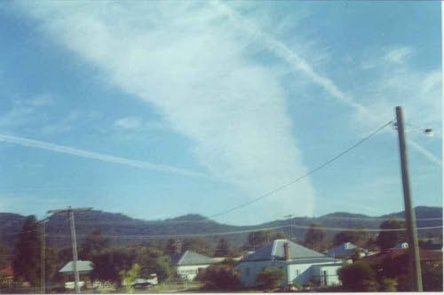
- 1) I looked out of the window and thought there was
a bushfire in the hills beyond the central house(that's what a big bush-fire
looks like >from here) Went onto the balcony and saw the sky was full
of contrails. Let's call the "bushfire" contraïl "A";
the thin one low and to the left contrail "B".The contrail to
the right is part of the eastern formation which wasn't photographable,
although some of those contrails were as thick as "A". When
the sun went behind a contrail shadows faded and it became noticably colder,
just as with a thick cloud.
-
-
-
-
-
-
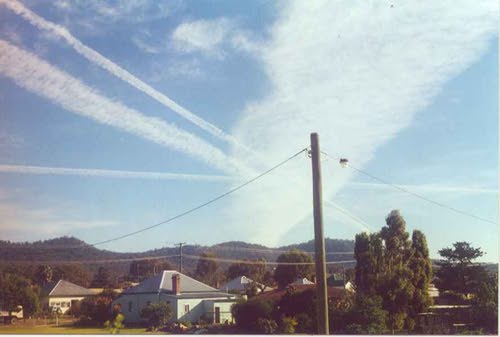
- 2) Same house in the centre. Note telegraph pole for
future reference."Bushfire" contrail has moved around - contrail
"B" has also moved higher and has been joined by parallel contrail
"C". Additional contrail "D" now also introduced close
to the hills.
-
-
-
-
-
-
-
-
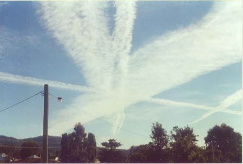
- 3) "Bushfire A" contrail still unmistakable
despite having moved round even further. Parallel contrails "B"and
"C" have grown and almost joined. "D" has also begun
to thicken .
-
-
-
-
-
-
-
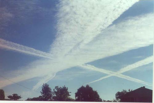
- 4) Nice big clouds now. The principle of Parallex might
give an indication of the length of the "bushfire" contrail.
The end close to the hills seems to have barely moved. If you can use
any of this please go ahead, or by all means pass it on to any of the experts
who can.
-
-
-
- Regards,
Denis
-

-
- SIGHTINGS HOMEPAGE
http://www.sightings.com
- This
Site Served by TheHostPros
|