| Back to... |
| Share Our Stories! - Click Here | |
Japan's Mystery 'Flying O-Ring' Coincided | |
| By Yoichi Shimatsu | |
|
Part 2 of this series on the Noto Peninsula earthquake by the Sea of Japan on New Year’s Day is focused on the mysterious O-ring cloud, its image captured nearby with mobile-phone wielding local driver in the early morning of December 9, eight days after the deadly temblor and tidal wave that killed some 400 local residents. The strange sighting is here traced back to a pair of experimental reactors in nearby Toyama Prefecture, the now-closed center of the world’s most dangerous experiments in nuclear fusion and mixed oxide (MOX) fuel power generation. This probe, along with the lack of previous seismic activity in the area, indicates that the Noto Hanto disaster was not act of Nature but instead triggered by human-sourced technology.
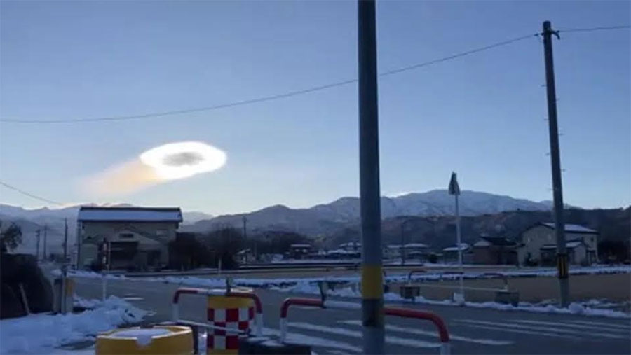
The shiny white donut in the sky left a trail of shimmering golden ripples across the early morning sky. The eerie hollow cloud was captured on camera phone by a local driver along a roadway in Kuroba, Japan, on January 9.. Since then (by now more than two weeks later) the relevance of that strange phenom was not recognized until I searched a map of Japan for the location of that rather obscure seaside town. Kuroba is located on the bay of the Noto Peninsula, the latter being where a powerful earthquake and tsunami leveled the town of Wajima, killing up to 300 locals and likely many more. The Noto quake occurred on New Year’s Day, January 1. The Kuroba saucer sighting occurred just eight days later, on January 9, coinciding with a powerful aftershock. Was it a weird bat out of Hell or could this eerie phenom have somehow been related to the Wajima mega-disaster? It was definitely not a “lenticular” cloud, as claimed by deceitful meteorologists, formed around a mountain peak, which would explain its hollow center. That claim is unadulterated chum for the masses posted by pro-nuclear propagandists for the nuclear industry. Lenticular (the term derives from the curvature of a lens) clouds do not emit a trail of zapping electro-charge particles as clearly seen in the drive-by video. The other strike against that bit of disinfo was that the O-ring in the sky was not moving away from the massive peaks of the Japan Alps but came from the opposite direction, moving from the west. It was arriving from Tsuruga Bay, the location of the decommissioned Monju fusion reactor and Fugen MOX nuclear plant, west of the quake epicenter. This ghostly emanation from those nuclear facitilies is in clear warning of the long-lasting radioactive threat of subatomic particles from nuke sites, The other “oddity” about this morbidt O-ring is its emergence coincided with a powerful aftershock eight days after the Noto Peninsula’s New Years temblor. And perhaps an underlying nuclear-sourced threat still looms large along the Sea of Japan. None of the facts are getting out of the Noto Peninsula where the quake relief work is led by Japan’s Self-Defense Force aka the army, which follows orders from the pro-nuclear Liberal Democratic Party (LDP), which orchestrated the massive cover-up of the secret underground nuclear weapons lab that triggered the Fukushima nuclear disaster. As long as the LDP is in power, Japan will remain a rogue atomic outlaw. So, here we go again.
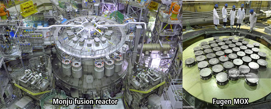
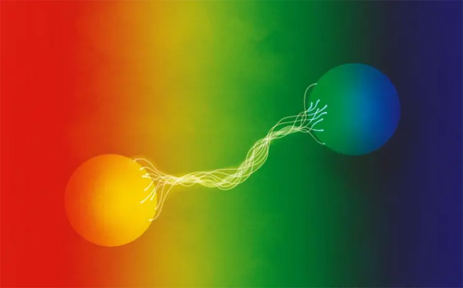
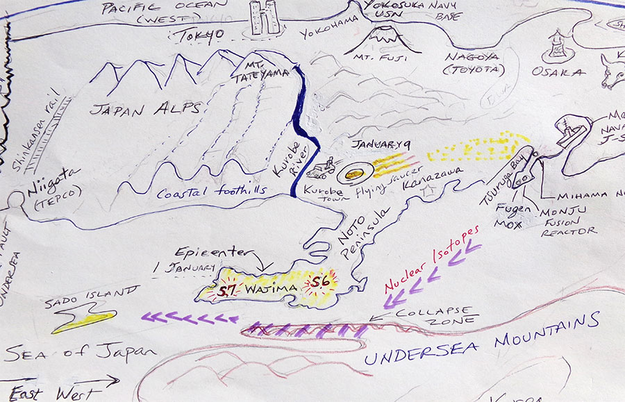
Mapping the Disaster One might note here that the phone-video taken from an outstretched arm of the anonymous driver of a moving car is the very essence of Surrealism, which is not reproduction of an imagined universe but instead a shockingly truthful account of the world as-is. It is a masterpiece of revelation that rings astonishingly true. Marcel Duchamps and Andre Breton would have been proud of that drive-by minute. That said, I am not a creative artist but merely a lowly scribe with a penchant for honest appraisal. Please then excuse my rather clumsy map of the quake affected region, which obviously is no masterpiece of art but instead is intended to illustrate causal factors for the quake while also debunking the blatantly false claims from nuclear apologists (scientists and a compromised news media) that the Pacific Plate’s collision with the Okhotsk Plate was to blame for the Shindo 7 upheaval (highest on the scale of quake vibrations). The pictorial approach enables us to recognize relationships between various sites, which otherwise might be completely overlooked and ignored. What compelled me to draw the map? The simple fact that the Noto Peninsula is not located in an earthquake-prone region, as compared with Niigata towards the east. The plate tectonics of this southern part of the Japan Sea and the Japan Alps are geologically stable, as compared with the quake-prone Niigata region along the Okhotsk Fault. The mystery of quake causality in a non-seismic zone demanded a sketch of the crime scene. Distances on the map are somewhat distorted to help readers more easily comprehend the relationships between sites. My objective here is not to casually disparage the nuclear industry or it lackey meteorologists but to prove without a shade of doubt as to the nuclear establishment’s responsibility for the “dance of death” that wiped out Wajima town. My hope is that more honest seismologists and other scientists (and journalists) from neighboring Korea, Russia and China might break with the insider secrecy of the nuclear club and launch serious scientific studies of that unnatural anomaly and its impacts on the Japan Sea (or West Sea) region, which hasjust added more radioactive contamination across the East Asian region atop the Fukushima mess. Meanwhile, the U.S. Department of Energy (DOE) as the world’s worst nuclear proliferator cannot be trusted in the least as was proven in the official Obama White House cover-up of its role in the Fukushima MOX fuel disaster. The main thesis presented here is that more than two decades of massive nuclear istotope releases from the Monju fusion “research” reactor and the Fugen MOX (mixed oxide) power plant into the Japan Sea had destabilized the fragile undersea mountains adjoining the narrow channel north of the Noto Peninsula, location of the worst-hit town of Wajima. Along that corridor, the New Year’s Day (O-Shogatsu) quake tallied Shindo 6 and Shindo 7 readings, the latter at the top of the earth-vibration scale. The anomaly here is that the Noto Peninsula, buttressed by the nearby Japan Alps, is not inside a quake zone. The O-Shogatsu disaster was not a natural event but instead a manmade catastrophe. A closer look The attached hand-drawn map (at the bottom of this essay) is turned upside down from its normal position to enable a view of the Japan Sea coastline at close range and with the Pacific region toward the rear. (The compass directions are off by several degrees due to the angle of slant, a distortion in terms of actual east and west, which has never been criticized by mapmakers and geographers.) The rising sun is added to the map to highlight this distortion. Distant cities on the Pacific coast are shown merely as familiar directional indicators; none are visible from ground level by the Japan Sea (which by the way is rarely visited by tourists, not only foreign but also the majority of Japanese). The Noto region, by the way, is located along the trail of Japan’s smoothest sake producers, from the cultural center of Kanazawa to the high-speed rail terminus in Niigata, a coastal region better known as the Snow Country. If you’ve already read Part I of this series, please excuse me for toppling the myth of this snowy realm as the homeland of the most beautiful white-complexioned innocent Japanese maidens, a fairytale that belongs in the category of romantic exoticism along with Turandot, Brunhilde and Disney’s version of Snow White and the Seven Dwarfs. Here, my aim is to push aside seductive myths including the dreams of a beautiful romance and safe clean nuclear energy, both of which arise from the human brain’s delusionary capacity for wish fulfillment. For the sake of human species survival, one must be ruthless toward mythical longings and instead stick to the facts, awful as these may turn out to be. . As that old reggae song goes: “If you want to be happy for the rest of your life, take an ugly woman for a wife.” Factuality and Ugliness are the intertwined twin pillars of sanity, as in the horrifying truth. “How”, you might ask, “can you live like that?” My answer is: It helps to quaff good snowy country sake to chill the blood in your veins, ice cold. Nuke Row Thus, on the right-hand side of the disaster map, there are along Tsuruga Bay: Five nuclear reactors with the Big 3 shown on the hand-drawn map: The Monju fusion toroid (by now demolished); Fugen MOX unit (under disassembly) and the operational Mihama conventional nuke. These monstrosities have been releasing vast amounts of subnuclear particles into and atop the Japan Sea, most of that atomic garbage flowing past the Noto Peninsula through a narrow undersea channel that passes by Wajima, the epicenter. The salient feature of this off-shore region is the adjoining undersea mountain chain, which in the prehistoric era was part of the ground-scape, that is prior to the rise of the Pacific ocean, which flooded the ancient basin. This narrow gap features a powerful southwest (westward) current and a lesser eastern current along the shore of the Noto Peninsula. High-speed subatomic particles are basically not influenced by water (or air) and their trajectories move like bullets through fog. As you can see on the map, the subnuclear particles are ejected along a 30-degree angle to hit along the submerged finger-like promontory of sandstone mountains, thus hollowing out the mix of weak sandstone. Various accumulated rocks from the ancient past, which include jade and chunks of granite, deflect the particles back along the channel.. Whatever particles survive by flowing directly toward Sado Island (which experienced aftershocks). The collapse of the offshore undersea mountains, possibly accompanied by releases of nuclear particles, account for the seven major aftershocks, dozens of minor temblors and a massive tital wave that rocked the Noto region, especially the ancient town of Wajima, sweeping hundreds of residents, along with their pets, cars and homes, into the channel. The Japanese government’s emergency rescue/response has been minimal, similar to the dismal efforts at Fukushima nearly 13 years ago. Japan under the hopelessly inept leadership of the drunkard loser Liberal Democrats is incapable of admitting and facing the facts. As in: “Oh, it’s perfectly safe to move back to Fukushima.” Corruption affects the brain. On the Eight Day Then, on the following week at 8 a.m. on Monday, January 8, a commuter caught the flight of the donut-shaped shaped cloud flying overhead. In a bogus claim, seismologists determined the O-ring was a “lenticular” cloud, meaning a hollow donut-shaped cloud that gathers around a mountaintop, The video by a passing driver revealed colorful electromagnetic waves inside the O-ring and “contrails” of purplish, yellow and orange being ejected from its tail. Those were obviously ionized radioactive particles. It took some effort to determine the vector of the O-ring (based on the angle of sunlight in the morning) to be southeasterly. Significantly, the weird cloud was not flying from the coastal foothills or the Japan Alps but, instead heading toward the gulf of the Noto Peninsula. Along that eastward pathway, my estimate for its origin was from the southwest. What lay along that vector, when elongated? Of course, the massive array of reactors along Tsuruga Bay, including the recemtly demolished Fugen MOX reactor, and possibly abetted by the sloppy messe from teh decommissioned Monju fusion unit. As seen on the map, the massive hard-rock gravity of the coastal foothills suppressed quake vibrations from the epicenter, meaning that the Niigata region to the east barely registered any earth movement. Located along the major Pacific Fault, Niigata experiences powerful quakes every 200 years on average, but felt hardly any shaking on New Year’s Day. This the Pacific Fault had nothing to do with the Noto quake. The seismologists who claim otherwise are apologists for the nuclear industry. In the interior toward Tokyo and Nagoya, earth movement was miniscule, if any occurred at all. This ground stability is due to the fact that the Noto region lays far behind the fault-collision zone. Protected by the massif of the Japan Alps, the region’s stability is also due to its far distance from the Pacific Plate, that crossed Honghu near Niigata about 200 km to the north. . Due to thei massive bulk of the Japan Alps, no quake damage or road disruptions were reported on New Year’s Day. Seeking Closer re-Entanglement? The moving cloud of subnuclear particles, glowing with radiant light, may well have originated from lonesome confinement under the massive foundation of the Monju torus (cyclotron). Paired, much like migratory birds, the separated particles were suddenly released by the New Year’s quake and began their aerial search for their unique mates, which have been trapped in the undersea hills off Wajima. That moment of release from bondage, for both partnered pairings, could have caused a massing of subnuclear particles determined to rejoin their lost mates. Buzzing like a bees in a hive, these particles lifted off from the Monju site and headed in a roundabout curve, passing through Kurobe to then flock like seagulls toward the Wajima coast on the Noto Peninsula. This behavior is much like the swans scattered from their summer feeding area in the shallow lakes of Apache Bosque north of Truth or Consequences in New Mexico. Three summers ago, while driving past that area, I witness a powerful electric storm that scattered the flock over hundreds of miles of separation from their mates, Since then, every summer these remnant groups have searched for their mates to reunify the flock. The December 9th “aftershock” may well have marked the reunion of trillions of paired subatomic particles. If so, at a larger scale, human plans for “recovery” from the New Year’s quake could soon be sabotaged by the powerful electromagnetic pulses of these rejoined particles from the heart of the Monju nuclear fusion reactor. Manmade power centers, for example the electrical power system for the Shinkansen Line between Niigata and Tokyo could well be fried by a storm of re-energized nuclear particles. We humans are not out of the woods yet, safely ensconced from the demons of our own invention.
Here is some data from the Monju and Fugen nuclear facilities: Pioneering nuclear tech innovations in the 1990s and 1970s, the Monju fusion torus and the earlier Fugen (the world's first MOX fuel reactor, the latter powered by highly radioactive 'mixed oxide fuel', both suffered breakdowns, radioactive leakages and controversy-plagued media cover-ups, Based on the French Astrid design employing sodium as a coolant, Monju did achieve fusion of hydrogen atoms to release vast amounts of nuclear energy. However, sustained fusion proved impossible for its engineering team. There is no public record on the series of failed experiments, which released vast amounts of high-energy particles into the Japan Sea region (without notification of local prefectures as to the potential risks). The unreported energy releases over the reactor's 22 lifespan, of subatomic particles as well as neutrons and protons went unreported by the plant operators and uncharted by independent nuclear scientists. The repeated tests are the probable cause of the destabilization (for lack of other possible stimuli) of the undersea mountains facing the Noto Peninsula. In 2012 Japanese seismologists warned that Fugen's high-energy particles could destabilize and trigger a major quake along the Urasoko Fault, located immediately north of the fusion reactor site. Fugen was the world's first operational MOX fuel reactor, powered by highly radioactive isotopes created inside other reactors rather than pure enriched uranium. This type of power source was identical to MOX energy-source inside Reactor 3 at the TEPCO Fukushima nuclear plant, which exploded, released vast amounts of radioactive particles into the Pacific Jet Steam (crossing over the USA) and actually knocked Planet Earth off its axis (destabilizing the North Pole to alter the world's weather patterns ever since. Tritiated heavy water was used as the coolent in Fugen, and released coolant allowed highly unstable tritium to leak into the Sea of Japan, another source of geological destabilization. Repeated operational problem resulted in a short life-span for Fugen of less than 25 years from project inception to closure. Much of the decommissioned reactor remains on site along with storage tanks of radioactive wastewater. Here again, powerful high-energy particles have the potential to destabilize undersea rock formations and trigger a massive quake as happened to the horrifically battered town of Wajima. So the conclusion is obvious, the nuclear industry and its political sponsors are again guilty of mass destruction and loss of human lives, as they were in the Fukushima disaster. In my opinion, the more powerful and responsible nuclear proponents should be put on trial and, if found guilty of unleashing a flawed mega-technology on the public, hanged like the war criminals following the Tokyo War Crimes Trials. They all had “good motives” and “well thought-out reasons” but their horrible miscalculation and repeated turning of a blind eye to the obvious problems, justifies the ultimate punishment for their ambitions and greed. Hang them high!
|