-
- Here they are, by popular demand: my ten favorite Mars
photos so far, from the 27,000+ that MSSS have put out on the internet.
I will include a little bit of commentary along the way. Keep in mind that
my musings are not meant to be definitive statements about what is on Mars,
but if I should happen to get something right, or very nearly right, along
the way, then, hey!, so be it. I offer the links to the photos and my comments
primarily to foster creative thought and discussion about Mars.
-
- What can I say, here we have all of these photos and
NASA/JPL/MSSS are saying next to nothing about the very interesting features
that appear in many of them. Judging from what is in the photos, Mars is
a remarkably fascinating place!
-
-
-
- Here, then, are my "Top Ten Favorites" (so
far):
-
-
- 1.
-
Detail #1
Detail #2
Get high resolution original from link below
-
-
- http://www.msss.com/moc_gallery/nonmaps/M0301713.gif
-
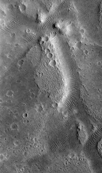
- This photo was found by an alert "Sightings.com"
reader. And it's a good one. There are many channels, canyons, basins,
craters and rills, filled with a multitude of parallel lines of ripples/dunes/ridges/dams/baffles.
You know, those "whatchamacallits" that some others have referred
to as "glass tubes" or "pipe" networks. Here you can
see that, whatever they may eventually prove to be, they almost certainly
are not "glass tubes" or "pipe" networks. In the aggregate,
they cover a huge area, and fill an extensive regional network of channels,
that itself has a somewhat regular, or "worked" feel to it. They
also occur in some, though not all, of the craters in the photo. The impression
I got looking at the whole complex is one of artificiality. Now these things
may certainly be a natural feature, but the feel I get from gazing down
at the terrain is that the whole area might well have been "worked".
But if it has been "worked", then by whom? Or by what? And when?
And for what reason?
-
- Are we perhaps seeing some kind of strip mining operation?
Are these things tailings piles? Or are we perhaps looking at an agricultural
operation? Is this a photo of the Martian Farm Belt? Are these fields of
crops? (Or the Martian equivalent of what we would call "crops"?)
-
- Are we perhaps seeing some sort of water control system
of dams or baffles built for the rare occasions when there is liquid water
on Mars? Are these features very old, or comparatively new, maybe even
in use today?
-
- Or are they some sort of life form that prefers to arrange
itself into neat, parallel ridges/dunes/heaps in the bottoms of dry stream
beds, channels and rills, and the occasional crater bottom?
-
- Or are we really looking at a natural, albeit strange
(at least to our eyes) feature of Martian topography?
-
- I don't know. In my mind the question is still unresolved.
We need more evidence, analysis and discussion. (I will even go so far
as to say that I, here and now, personally volunteer to go to Mars to inspect
these many mysterious features if my completely safe, and timely, passage
to, on and from the Red Planet can be assured, along with "total recall"
of all that transpires before, during and after the trip!)
-
- One of the most interesting features in this photo full
of interesting features, occurs about 25% of the way down. There is a crater
whose bottom is covered by the "dunes". But on the left side
of the crater, reaching out from the rim onto the crater floor like the
three prongs of a trident, are three white projections. What are they?
They certainly appear to be constructed, i.e., artificial and not a natural
part of the terrain. Are they roads? Ramps? Tubes? Tunnels? Something else?
Notice that they originate right up against the crater wall. Is there something
underground there -- are the white projections a means of access to the
Martian subsurface for someone or something?
-
- And finally think about this photo that I included in
"Curious Martian Anomalies: Part I."
-
- http://www.msss.com/moc_gallery/images/M0204841.html
-
- Notice the artificial feel of the network of rills that
I initially referred to as a network of "veins". It simultaneously
has the feeling of being engineered, versus being a completely natural
network of rills, and also of being alive. I wonder, if we could see the
network of "veins" close up, if their bottoms would be covered
with the orderly marching rows of "dunes" we have seen in so
many canyon and channel bottoms by now? I suspect that that might indeed
be the case, because the context image for which the first image above
was taken looks like this:
-
- http://www.msss.com/moc_gallery/images/M0301714.html
-
- Notice the similarity in the two images. We appear to
be looking at the same type, or class of feature in both photos. I am fully
prepared to admit of the possibility of life on Mars. And should there
be life on Mars, whatever else we might say about it, it will, besides
being alive, be different, be "alien", if you will, if only because
Mars is a different, hence, "alien" world. In my opinion, it
is possible we are seeing life, or the activities of one or more life forms
in these photographs.
-
-
-
-
-
- 2.
- Click on picture to load large scale image
Get high resolution original from link below
-
- http://www.msss.com/moc_gallery/images/M0300957.html
-
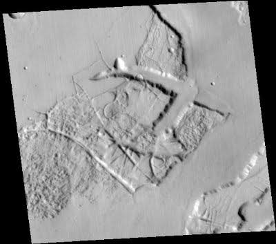
- What is it? It almost looks alive, doesn't it? Can a
land form be alive? Has the terrain here been engineered by someone or
something? Or is it just beautiful Martian geology? You decide.
-
-
-
-
- 3.

Click on picture to load large scale image
Get high resolution original from link below
-
-
- http://www.msss.com/moc_gallery/nonmaps/M0306104.gif
-
- This is a big file, but it is a wonderful close-up of
a crater "splotch". The four leading candidates for the dark
spots so far seem to be: a) rocks protruding from under snow and ice; 2)
rocks protruding through sand and dirt; 3) depositions of dark-hued, wind
blown sediments; and 4) clumps of Martian life. Take your pick of the possibilities
or advance an idea or theory of your own. My personal bias is in favor
of the Martian life possibility.
-
-
-
- 4.
Click on picture to load large scale image
Get high resolution original from link below
-
-
- http://www.msss.com/moc_gallery/images/AB102406.html
-
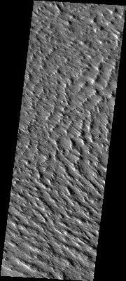
- For many years now there has been a rumor making the
rounds in the far fringes of UFOlogy of clandestine, or covert military
operations on Mars. I first heard these rumors more than 10 years ago and
dismissed them as fanciful tales, devoid of substance. And then I ran across
this photo, with its intriguing caption referencing a "Radar Stealth
Region" on Mars. The Pentagon employs "stealth radar" technology
on its most advanced warplanes. Is there something going on on Mars that
we are not being told about? Or is there a simpler explanation for the
phrase, "Stealth Radar Region", in the Martian context?
-
-
-
- 5.
-
- http://www.msss.com/moc_gallery/images/AB113005.html
-
- While on the topic of possible "black" operations,
or clandestine military activity on Mars, here's a real "black"
image, or as the caption says, "BAD IMAGE (BLACK). " There are
more than a few of these "bad" or black" or extremely degraded
images in this MSSS Mars photo collection. MSSS say they have posted 27,000+
photos to the web, but I have found a good number of them like this one,
i.e., (non)photos. Nothing at all but a URL, a web address with no substance
behind it, a mere digital shadow without a name or form.
-
-
-
- 6.
-

-
-
- http://www.msss.com/moc_gallery/images/M0100039.html
-
- "NA Dark Current Image". What's on Mars? You
will never find out from a (non)photo like this. "Black ops",
or just routine NASA/JPL/MSSS (non)photography? You decide.
-
-
-
- 7.
Click on picture to load large scale image
Get high resolution original from link below
-
-
- http://www.msss.com/moc_gallery/images/M0302687.html
-
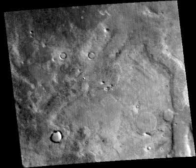
- "Plains North of Deuteronilus". This shot cuts
across an area immediately adjacent to an ancient river bed. To my eye
there are a number of straight, parallel lines in the landscape where this
image was made (I am not referring to the many, vertical scan lines) that
hint at the possible, heavily eroded outlines of massive quays and wharves.
It seems to me that when the river was full of water that such a location
might have been a fitting site for a port. There were rivers with flowing
water on Mars in the past. We know that. We can see them all over the planet.
Were there also ships plying those Martian waters of long ago? I wonder
-
-
-
-
- 8.
-
Click on picture to load large scale image
Get high resolution original from link below
-
-
- http://www.msss.com/moc_gallery/mediummaps/M0402619.jpg
-
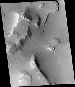
- You read it here first. When I posted this image I observed
that it looks like there are "seeps" or water "springs"
coming out of the cliffs here. Just four days later NASA and MSSS held
a surprise news conference to announce that they saw evidence in more than
150 photographs that indicated possible water springs flowing from the
sides of many canyons and crater rims. I am chalking this one up as a "hit".
-
-
- 9.

Detail Image #1
Detail Image #2
#2 with Contrast Adjustment
Get high resolution original from link below
-
-
- http://www.msss.com/moc_gallery/nonmaps/M0201818.gif
-
- Another one with terrible contrast. Overlook that for
the moment, and focus on the honeycomb pattern of polygons at the top.
This pattern is clearly not an artifact of the digital imaging. But what
is it? This is the only photo that I have seen in which such a feature
appears. The more I look at the Martian landscape the more I wonder if
it is alive! Yes! What if the landscape itself is alive and self-aware
and growing and changing?
-
- If the contrast were not so terrible I believe that more
"Dalmatian spots" would be visible in the light areas farther
down the image, as well. And then there are more ripples/ridges/dunes/baffles
-- whatever those things are. Altogether an extremely interesting photo,
that is hard to view because the contrast is so very poor. Why is it that?
-
-
- 10.

- Detail #1
Detail #2
Get high resolution original from link below
-
-
- http://www.msss.com/mars_images/moc/may_2000/meridiani/meridiani_100.gif
-
- This photo was also discovered by an alert "Sightings"
aficianado. Look at the interesting "city"-like structures near
the top, which contain many rectilinear lines. Notice, too, the many craters
that contain straight lines just inside their rims, and other noticeable
geometric regularity in and around their near vicinity. These features
can be most clearly seen in the craters in the bottom 50% of the image,
and especially in the concentration of craters in the bottom 10% of the
image. To my eye, these craters look worked.
-
- It certainly looks to me as if somebody, or something,
is on Mars right now, and very active.
-
- That's it folks! "Sauder's Top Ten Mars Photos"!
-

-
- MainPage
http://www.rense.com
-
-
-
- This
Site Served by TheHostPros
|