When I learned they targeted
the INSIDE of a crater to land in, my curiosity was peaked. NASA had
trouble with past rovers getting into craters and not being able to
get out. There must be a damn good reason for intentionally landing
in one. The Curiosity mission cost NASA several BILLION dollars. Why
would they risk it?
Gusev crater on another part of Mars is about the same size as Gale
crater where Curiosity landed. Gusev crater was the destination of an
earlier rover, which explored it for several years back in 2005. In
my 2005 book "What NASA Isn't Telling You About Mars," several hundred
NASA photos proved that Gusev crater is strewn with numerous artifacts
of buildings and mechanical devices.
Why was Curiosity sent to land in Gale Crater which could terminate
the mission with deep sand? Perhaps to look for ruins created by intelligent
life.
One of the comments made during last night's landing broadcast of Curiosity
was this - "With Curiosity we'll be able to look for past signs of life
on Mars." This too, is a joke since the Viking Lander back in the seventies
already found bacterial life on Mars. Perhaps NASA isn't looking for
bacterial life - but something that walked around on the planet.
Maybe the reason for landing IN Gale Crater is not to look for water
but to look for ancient ruins. If you had the task of deciding where
to land on Mars, wouldn't you choose a site using orbiting spacecraft
photos which show unusual signs of intelligent life?
The circled area below added by NASA is the location of the landing
early morning on August 6, 2012. I appears to have landed in a relatively
featureless area:
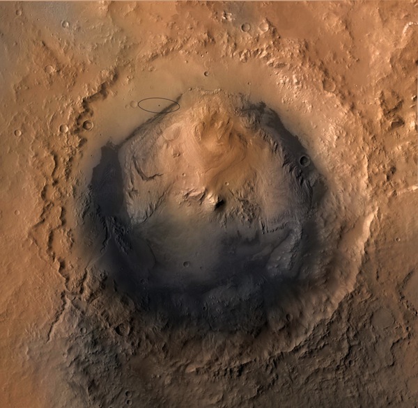
Fig. 1 - Overall image of Gale Crater. NASA states this image is a compilation
of images from three spacecraft. When looking at images, one must be
mindful of image-stitching artifacts. These can create objects which
do not exist. No apparent image-stitching artifacts appear to exist
in the source image. If they did, these artifacts would appear as pixel
distortions in straight horizontal, vertical or diagonal lines.
Below is a enlargement on the above hi-res image around the landing
site.
This enlargement pushes the limits of source image resolution without
creating severe pixelation:
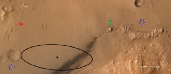
Fig. 2 - Enlargement of Gale crater wall around landing site shown in
Fig. 1. No other image processing was performed on this image to prevent
introducing unwanted artifacts. Considering the source image (Fig. 1)
was created by NASA using three different spacecraft images, image stitching
quality is surprisingly good.
Graphic notations from top to bottom:
White arrow - probably a dried-up ancient river.
Gold arrow - possible pyramid-like object
Red arrow - raised rectangular structure (note ridges radiating from
each corner)
Green arrow - possible building. A shadow to the right of the structure
is visible. Appears to be standing alone.
Blue arrows - point to other possible ruins on Mars. The upper right
corner may be the location of several ruined buildings or something
else.
It's also interesting is that this landing site is located within reach
of all these areas. But yet again NASA stayed away from landing
a rover at Cydonia. Maybe they believe exploring pyramidal structures
there would be too much for their own people to handle? Or perhaps they
have been told to stay away form it.
This site indicates NASA is looking for far more on Mars than just following
their mantra they endless repeat, "Follow the water...follow the water..."
On Earth when you look at coastlines, lakes and streams you will also
find all the major cities around the world. If other beings lived on
Mars' surface in the ancient past, why wouldn't they do also build cities
near water? It may be possible that this crater area was once filled
with water when a civilization lived on the surface.
We'll be watching...
Ted Twietmeyer
tedtw@frontiernet.net
|