- Image: Google
Satellite Imaging
Click
here to see original post and comments
-
- Tensuns says:
-
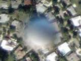
- I have no idea what this is. I can't find anything similar
on any google map referenced sites. It doesn't show up on terraserver and
I live nearby so I know there are no towers in that area. It has the same
shadow as ground objects and when you zoom out it appears to be too small
to be something really close to the satellite.
-
- Well we're completely stumped. Any clues anyone?
-
-
-
-

-
-
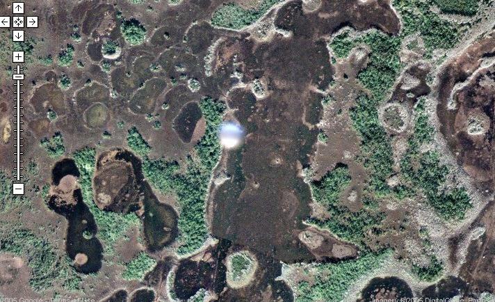
The following image submitted by Tony Fletcher
-
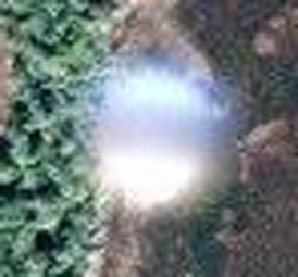
- Blow Up
-
-
- Tony notes that if you pan left from the first
UFO in Google, this
second orb is visible. Comments at the site suggest there are several orbs,
in fact.
-
-
- By way of comparison, the following images from
Google Satellite...
-
-
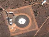
- The "Tethered Aerostat Radar System"
is a balloon-borne radar primarily used to provide radar data to US federal
agencies involved in the "war on drugs".
-
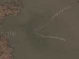
A flock of Geese
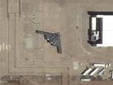
- Parked Stealth Bomber
-
-
- Comment
MNelson
5-17-5
UFO caught on Google Satellite Maps? I have no idea what this is. I can't
find anything similar on any google map referenced sites. It doesn't show
up on terraserver and I live nearby so I know there are no towers in that
area. It has the same shadow as ground objects and when you zoom out it
appears to be too small to be something really close to the satellite.
-
-
- Comment
Phil
- 5-17-5
-
- (Phil suggests that these photos are from high altitude
planes/jets, and not satellite. He explains:)
http://edc.usgs.gov/guides/napp.html
-
- this is a url to the current national aerial photography
program.
-
- The satellite images google uses are the images you see
when you are zooming in on the planet. after you zoom so far it will either
switch to the patchwork aerial photos pasted together or it will say something
like "no data available". Try zooming in to a rural area someplace
in the usa, you wont get that high detail, but with LA or Detroit or
some big city you will see the aerial photos and you can see they are pasted
together where the colors dont quite match or you can see the photos were
taken at different times of year.
-
- I have attached a preview image from that website, of
course the original image area would be 9" by 9"
-
- Phil
-
-
- Are the UFOs Just Grind Markers?
Comment
Josh Hared
5-17-5
-
- Found some info I thought Rense would appreciate:
-
- They're all in alignment with each other. I'd bet they're
alignment points for the map data.
-
- If you zoom out to the 3rd level and scroll left/right
and up/down in a straight line, they form a grid.
-
- http://maps.google.com/maps?q=33409&ll=26.748651,-80.189370&spn=0.005622,0.007875&t=k&hl=en
http://maps.google.com/maps?q=33409&ll=26.748705,-80.074496&spn=0.008122,0.014956&t=k&hl=en
http://maps.google.com/maps?q=33409&ll=26.901956,-80.245299&spn=0.008122,0.014956&t=k&hl=en
http://maps.google.com/maps?q=33409&ll=26.901956,-80.357441&spn=0.008122,0.014956&t=k&hl=en
http://maps.google.com/maps?q=33409&ll=27.002410,-80.243819&spn=0.008122,0.014956&t=k&hl=en
http://maps.google.com/maps?q=33409&ll=26.902256,-80.076728&spn=0.008122,0.014956&t=k&hl=en
http://maps.google.com/maps?q=33409&ll=26.902760,-80.302366&spn=0.008122,0.014956&t=k&hl=en
-
- Note also how they're more or less identical in shading.
Light on the bottom, dark on the top. #4 above and #7 above are partially
overwritten by new data.
-
- Keep up the good work. :)
-
- Peace. - Jared . H.
|